


Devizes Castle, Devizes, Wiltshire
Devizes is not mentioned in the Norman Domesday book of 1086 and there were no major settlements at that time. Potterne, Rowde and Bishops Canning were however mentioned. It is highly possible that some of the Castle mound dates to the Iron Age. There were scattered Roman villas in the area, around the Green, on Nursteed Road and Pans Lane. Roman pottery has been found on the Castle mound.
By the early 12th century Devizes castle was started - at first as a mottle and bailey castle in wood. The Castle was built as a strategic centre of power to help secure the Norman conquest. It was on the boundaries of three manors - Rowde, Bishops Cannings and Potterne. It became known by its Latin name Castrum ad divisas - the castle at the boundaries, which evolved through the Vyses to an anglicised Devizes. Up until the late 14th century the castle was a major fortress in England and played a significant national role. But by the end of the Civil war in 1645 it had been reduced to a bare hump by stone quarrying and Cromwell's orders. What we see today is but a fraction of the size of the original castle. The modern castle was begun in 1838 and the first phase finished in 1840 by Valentine Leach, a local tradesman. Devizes Castle Photogallery
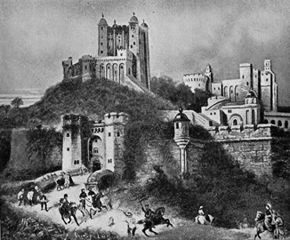
Above right.An artistic impression, based on his archaeological work, of Devizes Castle in the 13th century by James Waylen of Devizes. The original is in the Devizes Town Hall.
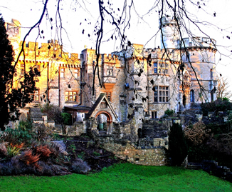
Above left a photo of the modern castle - western side - at sunset 2009.
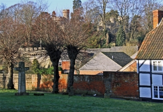
Righta glimpse of Devizes Castle seen from St. John's Churchyard. This church yard is very interesting. It contains a1616 Sexton's Cottage and leads across the abandoned old railway via a pedestrian bridge. This bridge gives a good view of the Castle and the gardens that were once the staple provider for the Castle.
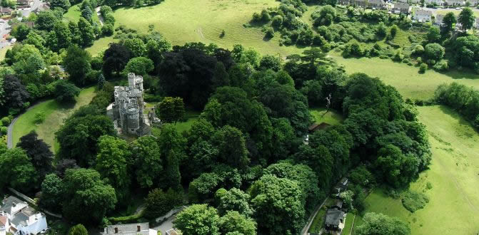
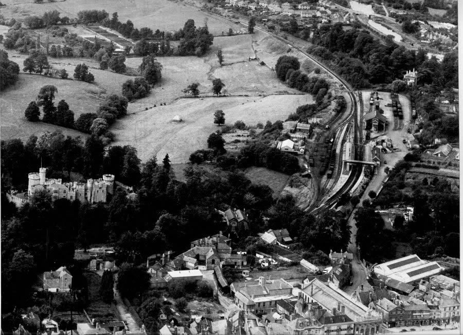
Above is an aerial photograph taken in 2009 by Neil Maw. West is towards the right of this photo. This church yard is very interesting. It contains a1616 Sexton's Cottage and leads across the old railway via a pedestrian bridge. This bridge gives a good view of the Castle and the gardens that were once the staple provider for the Castle
Devizes Castle - a history and listing as a monument
The Castle was built as a strategic centre of power on the boundaries of three manors - Rowde, Bishops Cannings and Potterne. It became known by its Latin name Castrum ad divisas - the castle at the boundaries, which evolved to an anglicised Devizes. What we see today is but a fraction of the size of the original castle. The modern castle was begun in 1838 and the first phase finished in 1840 by Valentine Leach, a local tradesman.
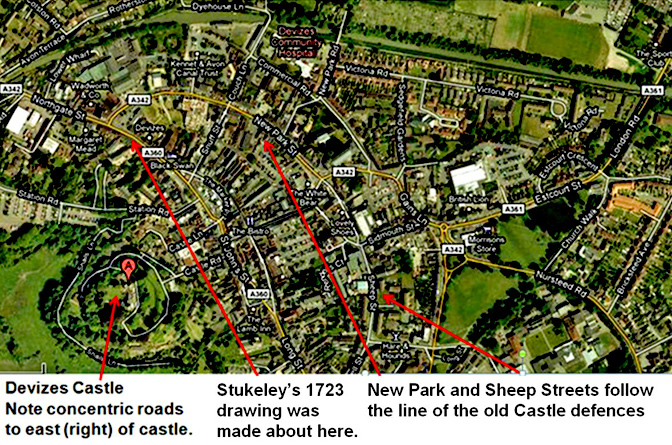
The castle was built on a small outlier of the spur, a naturally defensible position, with the outer bailey and town on a flat shelf of land on its eastern side. The shape of the town defences defined the layout of the town, with its concentric arcs of streets with radial roads at the cardinal points marking the old town gates. Castle Photogallery
As the castle was built on a naturally defensive site with access to water it is possible that the motte and bailey had a prehistoric precursor, but the first documentary evidence for the castle is in 1106 when Robert of Normandy was imprisoned there.
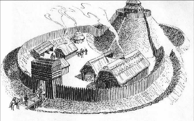
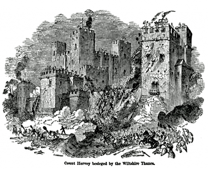
The Castle was initially a wooden construction - a motte (mound) and bailey castle as Above. This burnt down in 1113 and was rebuilt in stone between then and 1121 by Osmund's successor to the bishopric of Salisbury, Bishop Roger. Between 1139 and 1141 the castle was further fortified, but fell to King Stephen, who leased it to Count Hervey from Brittany. He had a difficult task because the west was largely a supporter of Empress Matilda and her "general" and half brother the Earl of Gloucester. In 1141 King Stephen was captured at the Battle of England and Devizes Castle was besieged by Wiltshire thanes under the direction of the triumphant Queen Matilda. Count Hervey left quietly after a short siege and returned to Brittanny. James Waylen in his 1859 History of Devizes had an engraving made of his Siege; it gives us an idea of the 12 century Castle.
From her it passed to her Plantagenet son the future Henry II who was holding it in 1152. From then until the 17th century it remained in the hands of the Crown. The town grew up and by 1141 became a borough. The first known constable was Guy de Diva in 1192 .
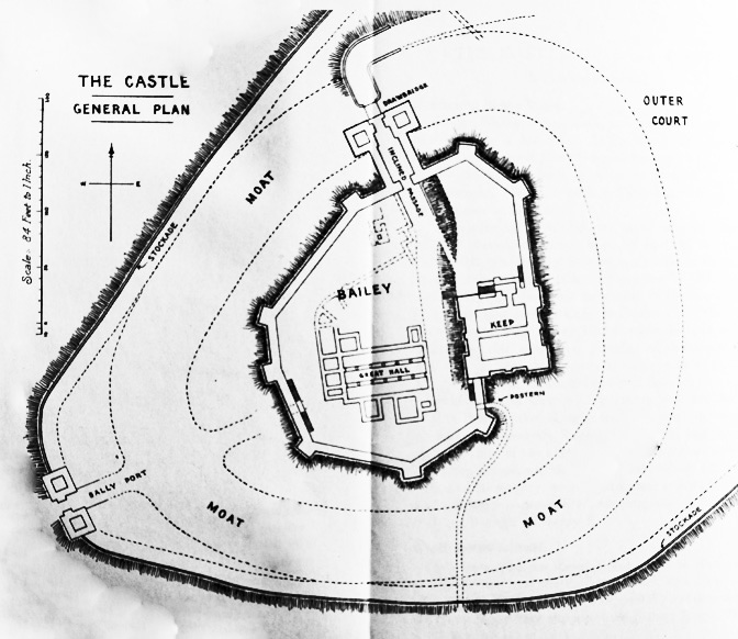
The new castle was evidently an impressive affair, and earned praise from several chroniclers of the time. According to Norden in 1610, it had five towers, two chapels, and a large hall and keep on a lofty motte, although by then it was largely in ruins. The keep and hall were surrounded by a curtain wall on top of the motte, which had its own ditch. Around this were arranged the buildings of the inner bailey, which occupied the remainder of the outlier described above. The bailey wall was augmented on three sides by the natural slope of the hill side, whilst the eastern side of the inner bailey was defended by a bank and a wide ditch.Below: a general view of the Castle and Town in the 13th century. This plan and the one below is taken from E Herbert Stone "Devizes Castle" 1920.
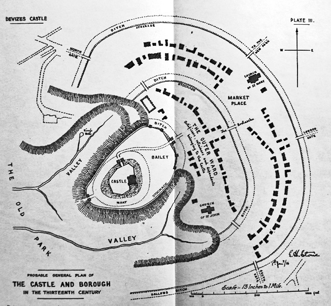
Below: a detail of the castle in the 13th century.
Below an annotated aerial view of Devizes castle and the town that grew up around it. The castle has had a huge influence in how and where Devizes has developed as a town.
Little remains of the first castle, although the early ditch found in excavations at the Corn Exchange in 1994 (Wessex Arch. 1994b) was probably part of the defences. Kite described the remains of Bishop Roger's castle in 1858 when the foundations of the keep and hall were exposed on the motte. Stone (1920) used various sources including Kite to draw up plans of the castle, showing the buildings, the wall and towers of the inner bailey, and the deep ditch which crossed the neck between the knoll and the main plateau on which the town stands.
The Outer Bailey defences have been examined in several places and are rather better known. The line of the ditch has been observed in three separate locations, twice during field evaluations (Estcourt Hill and the rear of 33 Market Place) and once during a watching brief (Vales Lane) and it can be shown that the line is fossilised in many modern property boundaries. The ditch is roughly 8m wide and 4 - 5m deep and the remains of an internal bank 8m across were seen in the Estcourt Hill excavations. It should be noted that whilst no continuous section across the ditch was available at Estcourt Hill, the archaeologists estimated the width to be in excess of 12m. If this was so, it may indicate a broadening of the ditch at this point where it opened into the valley or met the castle ditch.
No trace has been found yet of the wall or stockade that presumably stood on the bank at any of the sites; nor is there any evidence for the gates into the bailey from the town. The ditch is usually assumed to have curved back at each end to meet the inner bailey ditch, but there is no evidence that this was the case at either the northern or the southern extremities of the bailey. The evidence relating to the date at which the rampart and ditch were levelled is at best ambivalent: pottery from the ditch at Estcourt Hill and 33, Market Place and from the Castle Lane landfill dated between the 12th and the 14th centuries, but at Vales Lane the upper fills of the ditch contained 18th and 19th century sherds. Since it is clear from the historic record that the levelling took place between these periods, all this indicates is that in some places at least, the infill must have subsided by the 19th century and required further levelling.
Several sources have commented on the location of the street …"the Brittox", meaning a bretache or barbican, in the outer bailey. The Victoria County History notes that the road through the outer bailey crossed two bridges between which in 1380 was a barbican. This reference, with the association of the street name, is usually interpreted as evidence for a bretache by the gate to either the inner or the outer bailey, although it is not known which. It could, however, equally well apply to the whole outer bailey in its effective role as an outwork or barbican to the castle.
Below: A very interesting old photograph - date? - showing the Castle and the Railway station and its yard. The Kennet and Avon Canal is just visible top right.
Throughout the 13th century a number of Kings and notables stayed in the castle, including King John who often visited between 1204 and 1216 and later Henry III and Edward I. Part of the castle was also used as a prison, and by the late 13th century the castle was becoming less of a fortress and more an administrative centre. It is clear that gradually, even before the Civil War, that the Castle was being used as a source of stone by local noble men. For example in the early 16th century Sir Edward Bayntun (1480 - 1544) enlarged Bromham House with over 1500 stones taken from Devizes Castle. It was a very stately and magnificent structure and appears to have consisted of three sides of a quadrangle with a great store of very rich furniture, a palace fit for a king. The building alone cost £15,000, the iron works about the house being as near as big as Whitehall cost £5,000 and it was capable of concealing 700 men.His heir - another Sir Edward Bayntun was the MP for Devizes Borough in the Civil War, a Puritan and was on the Parliament side as Captain of Horse in 1642 and a Major in 1644. During the Royalist occupation of Devizes Castle in March 1645 Bromham House was burnt to the ground by Royalist forces. Edward Bayntun rebuilt a new smaller House at Spye Park near Lacock using some of the stone from Bromham House. He was present at the restoration of the Monarchy in 1660.
During the early part of the Civil War Devizes castle was was Royalist fortress; the Castle was pressed into service, barricaded and defended. Sir Ralph Hopton was wounded at the Battle of Lansdown and was carried on a chair from Bath, to Chipenham and on to Devizes.His forces were harassed by Sir William Waller's advance guard and Hopton lost 40 men at Rowde and Rowdeford just 2 miles from Devizes.The Castle provided a base for Lord Hopton's force during the Battle of Roundway Down in 1643; whilst the Parliamentarians camped to the north in Roundway and had a force in Potterne too. The castle and town were bombarded by parliamentary guns and there was hand to hand fighting as far into town as Morris Lane. The Battle of Roundway in July 1643 was the most important Royalist victory of the first Civil War.
Oliver Cromwell, in person, captured the Castle in September 1645. The Castle was well stocked with food but it was held by only 400 Welsh troops under the command of Sir Charles Lloyd - the King's Chief Engineer and and Quarter Master General. Guns were fired from the market Square by Cromwell's men. The Royalists wisely surrendered to the overwhelming 5000 strong Parliamentary army. Cromwell ordered the castles destruction, but this slighting did not take place until 1648. Subsequently the large Castle was dismantled piece by piece and its stone used for local building works. The Time line link shows events in the first part of the Civil War 1642 to 1649.
Below is Dr. William Stukeley's1723 sketch of Devizes including the Castle remains - with two windmills on the site; St Mary's Church is on the left and St. John's Church on the right. The artist is standing some where in Northgate.
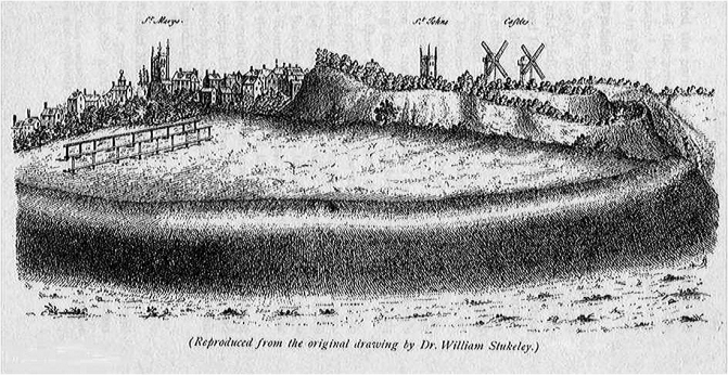 By the
early 18th century the castle had all but disappeared. Stukely's
drawing of the town in 1723 shows that whilst the motte and
ramparts appear to be still largely intact, the only buildings on the
mound were a pair of windmills, which remained there until 1840, when
they were demolished to make way for the present house. The first of
these appeared soon after the slighting of the castle and is shown on
the 1654 map of the Old Park. It is said that the tower of the newÂÂÂ
house stands on the foundations of this windmill, which was itself built
on the base of a medieval tower.
By the
early 18th century the castle had all but disappeared. Stukely's
drawing of the town in 1723 shows that whilst the motte and
ramparts appear to be still largely intact, the only buildings on the
mound were a pair of windmills, which remained there until 1840, when
they were demolished to make way for the present house. The first of
these appeared soon after the slighting of the castle and is shown on
the 1654 map of the Old Park. It is said that the tower of the newÂÂÂ
house stands on the foundations of this windmill, which was itself built
on the base of a medieval tower.
The keep and aisled building were first excavated in the 19th century. Excavations in 1858 revealed a number of lesser buildings surrounding the hall. The castle ditch, or moat, was excavated in 1860, and was found to be 14m (45ft) deeper than the exposed portion. A number of features are excluded from the scheduling: these are the building known as Devizes Castle, The Gate House, Moat Cottage, all walls and gateways, the bridge, sheds, the surfaces of all roads, and all garden features and ornaments. The ground beneath all these features is, however, included.
The Castle we see today - a Victorian creation
In 1838 the castle estate, in its shrunken condition, had become owned by the bank in St. John's Street - in the hands of J. N. Tylee. Tylee sold it in 1838 to Valentine Leach a Devizes tradesman. Leach built himself an imposing castellated residence; he built the Round Tower on the ancient site of the Norman keep demolishing the southern most windmill. He preserved the northern most windmill tower and incorporated it into the new building adjacent to the Round Tower he built a stable block and coach house. On his death in 1842 he was buried in the churchyard of the Congregational Church on Northgate Street.
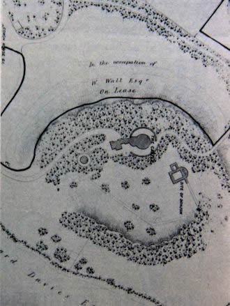
His son Robert Valentine leach tried to sell the house, which by then was styled Devizes Castle. The 1843 sale catalogue (below) shows plans and drawings which reveal a deal about the Castle's recreation at this stage. Below left is the unsuccessful 1843 auction for a fee of 1 guinea per year. Below left a plan of the1843 castle from the 1843 sale brochure - below right
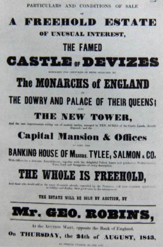
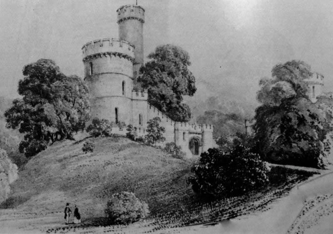 Left a drawing of the Castle's South Tower, from the south-east, in the 1843 sales brochure.The
sale attempt failed, some parts of the estate were sold off, and Leach
left the town.The castle was let and the grounds were opened as a
pleasure ground to a limited public for a fee of 1 guinea per
year. He purchased a large house in Briton Ferry in South Wales
and converted into a successful Lunatic Asylum. This was financially
successful and in about 1860 Leach returned to Devizes. For the
next 20 years he occupied himself in enlarging the castle and
introducing Norman constructions into the grounds. Extensive
excavations were carried out in 1858 and it was at that time that the
footings of the former hall piers were examined.
Left a drawing of the Castle's South Tower, from the south-east, in the 1843 sales brochure.The
sale attempt failed, some parts of the estate were sold off, and Leach
left the town.The castle was let and the grounds were opened as a
pleasure ground to a limited public for a fee of 1 guinea per
year. He purchased a large house in Briton Ferry in South Wales
and converted into a successful Lunatic Asylum. This was financially
successful and in about 1860 Leach returned to Devizes. For the
next 20 years he occupied himself in enlarging the castle and
introducing Norman constructions into the grounds. Extensive
excavations were carried out in 1858 and it was at that time that the
footings of the former hall piers were examined.
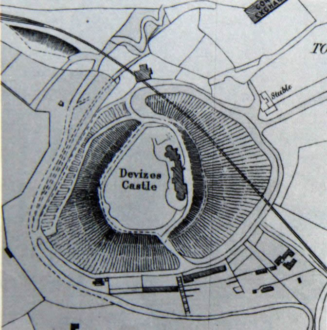
Right a plan of the castle for its sale in 1888. Note the railway in its tunnel under the castle. When Leach died in 1888 the property was bought at what was then thought to be a bargain price by Sir Charles Rich, Bt. (d. 1913). He altered the house but seems not to have shared Leach's antiquarianism, for in 1903 the earthworks were much overgrown. On the death of Lady Rich in 1918 the property was purchased by E. C. Reed, whose trustees sold it after his death to R. J. Clappen. In 1951 Mr. H. Brown, a Birmingham builder, bought it from Clappen. and divided it into two lots. One, the 'North Tower', he sold to W. B. Medlam who sold it in 1955 to Mr. E. B. M. Kemp. The other, the 'South Tower', he sold to Mr. T. G. Waugh, from whom it was purchased by R. N. Newsome and Miss Delia G. M. Tudor-Hart in 1956. From them Mrs. I. M. Durand bought it in 1961.
The modern mansion
The irregularly-shaped stone mansion owes much to the two Leaches. Valentine replaced the southern windmill tower by a massive circular one, the principal part of his new residence. The building was designed to suggest an embattled Norman castle by H. E. Goodridge of Bath. On the east front was a large round-arched entrance with machicolations and a portcullis and above the tower parapet rose a look-out turret containing a spiral staircase. The northern windmill tower was preserved and crowned with battlements. R. V. Leach's northward extensions, built piecemeal between about 1860 and 1880, trebled the size of the house. They incorporated the windmill tower of which the original brickwork is still visible. Leach inspired the design but J. A. Randell co-operated with him as architect. They carried on the 'Norman' theme, but their work, both inside and out, is far more ornate and fanciful than that of Goodridge. At the north end of the house they built an octagonal conservatory, connected to his drawing room by a curved and arcaded 'fernery'. Various ornamental features in the grounds, notably the so-called St. John's or Bishop's gate, are partly constructed of genuine 12th-century fragments from St. John's church, the west end of which was being rebuilt in 1862. Leach's last work was the entrance lodge, in the form of a Norman gatehouse, on the approach road from St. John's Street. Alterations made to the house by Sir Charles Rich at the end of the century included the replacement of many 'Norman' windows by larger ones of Tudor design. He also built a billiard room and new stables. In 1971 the mansion was occupied as three dwellings and the gatehouse lodge was being converted into a substantial house.
The present situation of Devizes Castle.
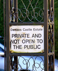
NEWS The Castle has been sold andis now occupied by Julia Dempster an English interior designer last August.She hopes, over, time to buy the whole site including the gatehouse. Maybe in time public acces to the grounds will be possible from time to time.
The Castle is now being marketed as for weekly rental purposes only £8000 per week will allow you to step where monarchs fought and played!
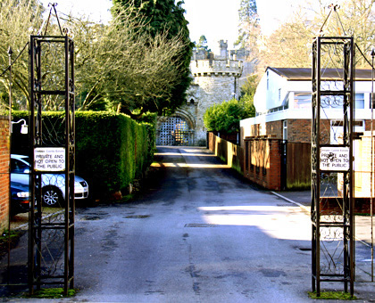
Below: Modern views of the castle from the town side
English Heritage Monument Listings for Devizes Castle
At the bottom of this section are the rather dry listings for three sections of the Castle
- the modern Devizes Castle; including Glass House and Garden Walls encircling West Side of mound, Devizes - Grade 1
- the gateway on the Town side viewable from St Johns Street, this contains some Norman features Grade 2
- Walls encircling top of Castle Mound Grade 2
- Remains of original Castle in the sunken garde west of present Castle Grade 2
General Description by English Heritage
The monument includes a motte and castle, lying on a hill with steep sloping sides, on the south west side of Devizes. The castle, as it appears today, is a Victorian folly. However, the folly is built on the motte of the original castle, whose moat still survives together with part of the inner bailey. Beyond the ditch is a grass sward and gardens which belong to the modern dwellings which lie around the castle. The east side of the castle grounds encompass the bailey, and enclosing the whole area is a stone-built wall. The castle keep stood on the highest part of the motte. Adjoining the keep on the west side was an aisled hall
of six bays, which was first mentioned in 1236-7. Around the hall were several other buildings.
The Castle was originally protected to the north east and the south by four concentric ditches. The outer two later formed the town fortifications. Near the Corn Exchange the ditch was double with steep sides 6m (20ft) deep. As the town expanded the bailey was reduced to the area between the inner and outer castle ditches. This area was reached by the road which is today called the Brittox, a corruption of the word Bretasche, meaning a timber structure associated with the defence of a gateway. The road passed through an outer gate and entered the inner precinct on the north side by the inner gate. Inside the gate was a courtyard called the inner ward out of which a postern led to the south west. The road crossed two bridges, between which was a barbican. The earthen bank above the inner castle ditch had a stone curtain wall, which is thought to have been repaired in 1240.
From about 1837 there was gradual redevelopment of the castle motte on the east side, with the gradual construction of what is now known as Devizes Castle, a house in the Victorian Gothic style, which is believed to sit on the site of the stone keep. This house is a Listed Building Grade I and is excluded from the scheduling, although the ground beneath is included. It is thought that the stone keep stood on the south east part of the motte, which is the highest part, and was the earliest building on the site, although it may have had a timber precursor. The aisled hall was to the west of the keep, and was presumably a later addition. Surrounding the motte is a ditch, which varies in depth and width, but is approximately 4m deep and varying between 10m and over 30m wide. The ditch has been partially landscaped and also affected by the construction of a railway tunnel. References contemporary with the tunnel construction suggests that the tunnel was dug through the fill of the ditch, whilst leaving the base of the ditch untouched. This indicates that the archaeologically sensitive lower levels of the ditch survive. On the east side of the ditch are the remains of the inner bailey. Map evidence shows that it originally extended further east, and beyond it was a second bailey which has since been incorporated into the town.
The scheduling has been drawn to include as much of the bailey as is known to have been unaffected by later developments and where archaeological evidence will survive. The whole of the site is surrounded by a curtain wall which may lie on the line of an original medieval wall. This wall is a Listed Building Grade II, and bears evidence of ex-situ medieval masonry, particularly in the gateway, but appears to be a largely Victorian construction and is therefore excluded from the scheduling. The ground beneath is, however, included. Map evidence indicates that the original entrance to the castle was an approach from the NNW. There is evidence of what is described as a sally port, but this is a Victorian structure on the south east side, which is thought to have provided access to the deer park. The entrance alignments have now been change. Devizes Castle walls are listed too, and the site is now approached along Castle Road and through the gatehouse which is a late 19th century structure and a Listed Building Grade II. The sally port, together with the modern additions to the gatehouse are excluded from the scheduling, although the ground beneath is included.
Listing for Devizes Castle including glass house, garden walls and encircling west side of mound, Devizes
Grade: I Date Listed: 19 September 1972 OS Grid Reference: SU0024961342 OS Grid Coordinates: 400249, 161342 Location: Castle Road, Devizes, Wiltshire SN10 1DB
The original castle built by Bishop Roger of Salisbury in reign of HenryI has virtually disappeared. It was partly in ruins in the C16, but finallydestroyed at the end of the Civil Wars by Order of Parliament. The siteis a magnificent one with a great mound and moat. The mound falls steeplyon 3 sides towards the undulating ground to the south-west. The rich parklandsof the Old Park form with the Castle mound a fine piece of landscape, whichshould always be preserved. The plan of the town in the form of a fan with the Castle as the centre of the segment, seems to be too formal to be a haphazard growth. It is reasonably certain that the town grew after the building of the Castle, and it would be interesting to know how far the plan was dictated by the Bishopric of Salisbury, so closely connected with the Castle itself, as occurred at a slightly later date in the case of Salisbury city.
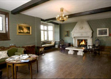
The existing structure was begun in 1842 by Goodridge of Bath. Highly asymmetrical.The ashlar faced keep and turret to the south are Goodridge with pairedlights divided by colonettes in narrow openings. The rest to the north is a massive rock faced enlargement of 1860's, 70's and 80's. Crenellated parapet, buttresses, superimposed bays, oriel windows and large mullionedand transomed windows. The north tower however, is partly of C17 brick and was originally a windmill. It's rubble base may be part of the original castle. Around the north tower's base, facing west, is a bowed fernery with stone tiled roof, round interlaced arches forming pointed lights with Norman style shafts dividing. Adjoining the fernery to the north is a fineglass house with octagonal base and a stepped domical roof with crowningfinial. The entrances are to the east and west: wooden gables with ornamented barge boards supported by flanking paired colonettes with foliate capitals,on high pedestals.A terrace surrounds the castle with a battlemented parapet. On the west side towards the centre are 2 short sections of arcaded wall, one incorporating in arch some original Norman stone work of zig zag pattern. The interiorof the castle is designed in a mixture of neo-Norman, Gothic and C16 styles.The drawing room and bedroom in the northern section facing west have thepartly original frames of C16 or early C17 ceilings inserted with carvedand gilded bosses, small brackets and ribs, the whole completed in plaster.
Scheduled AM.Listing NGR: SU0024961342
Gate House of Devizes Castle (modern)
SU 0061 2/217A Grade 2
Dating from the later phase of the present castle's expansion, circa 1860 rock faced gate house. Large round tower and Lower Square tower flanking gateway with machicollated, crenellated parapets. The double gird pattern timber gates are set in a large Norman archway, flanked by heavy shafts with cushion capitals. Above the arch linking the towers a deeply machicollated parapet with zig zag, the centre merlon stepped up with coat of arms. To the town front there are only slit windows but facing the castle, the round tower has small deeply recessed Norman windows and 3 larger ones with leaded casements, the ground floor one with double gabled drip mould, the others with arched drip moulds. Round headed doorway with drip mould decorated with lion head at crown. The square tower has 1 similar small 1st floor window and similar doorway on ground floor, the door with diamond battens and diamond light. Picturesque. Listing NGR: SU0032861361
Walls encircling top of Castle Mound
SU 0061 2/217B Grade 2 Extensive rock faced, partly crenellated, walls encircle castle mound and sunken garden. There are several Norman arched gateways under gables with pierced openings.
Remains of original Castle in the sunken garden west of the present castle
SU 0061 2/2l7C Grade 2
In the sunken garden, to the west of present castle buildings, part of the foundations of the original keep are visible.Listing NGR: SU0022361305